Exploring the Sacandaga

At 3.9 miles from the Eleventh Mountain Trailhead, you’ll cross the East Branch Sacandaga on this ancient suspension bridge, which is part of this hike’s charm.
Bill Walker and I have been exploring the Hudson River for the last year. The First Wilderness Heritage Corridor is all about the Hudson, the corridor being made up as it is by ten towns along the Hudson, running from Palmer Falls at the southern border of Warren County in Lake Luzerne to its northern border at Mouse Rapids near North River. This is the corridor through which Thomas Durant built the Adirondack Railroad between Saratoga Springs and North Creek and opened the wilderness to tourism and such industry as logging, mining, potash production, and tanning.
We told this story briefly in Rediscovering the First Wilderness, the six-page feature that the Adirondack Mountain Club published in Adirondac magazine in last year's September/October issue.
Now we're exploring another of Warren County's great rivers: The Sacandaga, which feeds the Hudson from the west. Its East Branch is of special interest to us, because it substantially defines the eastern boundary of the Siamese Ponds Wilderness, the terrain that Paul Schaefer called Cabin Country.
Consider this description by Adirondack Wilderness Advocates:
"The Siamese Ponds region is the Adirondack Park’s quintessential wilderness area: vast in size, diverse in both terrain and forest cover, and available to explore at any time of the year. Everything a wilderness should possess can be found here, and it seems impossible to ever tire of exploring this place.
"Like the four other largest protected areas in the Adirondacks – High Peaks, West Canada Lake, Five Ponds, and Silver Lake – the Siamese Ponds Wilderness far exceeds the size of any National Forest wilderness in the Eastern U.S. While not quite a superlative area like the High Peaks region, it is based on the same foundation of anorthosite bedrock. It is also a land of extremes, with numerous high, densely-forested summits that few people visit, divided by wide valleys through which flow a vein-like network of wild streams. Elevations top out over 3400 feet but dip to nearly 1000 feet above sea level."
As Kirstin Seleen of the Department of Environmental Conservation told us, this area has some of the first parcels of the Forest Preserve, which became constitutionally protected in 1895 with the implementation of the Forever Wild clause. This was an area that truly needed protection, as we know from this story that The New York Times published in 1889, which paints a picture of devastation:
"Everywhere one encounters ruin. Yet five years ago, this country was covered with heavy timber. The streams were filled with trout and carried enough water to make the Sacandaga so powerful in its sweep toward the North River that neither tanneries nor sawmills had to employ steam as a motive agency. There were few signs of fire then. Now, on every mountainside, there are acres of charred stumps and bleached rocks where the flames have swept over and have destroyed the vestiges of woodland which the lumberman left."
The unidentified writer goes on to describe the poisoning of the river by the tanneries at Oregon and Griffin:
"The foul combination of the hemlock juices and malodorous hides flows in an inky stream into the river which kills the fish that have the misfortune of swimming into it from their mountain streams."
Six years later, voters would approve the addition of the Forever Wild clause to the New York State Constitution, strengthening the protections that had been imposed when the State Forest Preserve was created in 1885. The writer suggests an investigation into the logging practices of George Freeman, who owned 28 square miles of forest in this area.
"An interesting count of stumps might be made in this place by the State authorities, for the penalty is a $25 fine for every tree belonging to the State that is felled for commercial purposes."
The writer describes:
"a dimly defined trail from Thirteenth Lake, in the northwest corner of Warren County, through Township 13, to the main Oregon road, about two miles north of the latter hamlet...This district is nearly exhausted of its soft or commercial timber, so thoroughly was the work of timbering done six or seven years ago, yet, with the wonderful vitality of this region where fire has not touched there is growing a second supply of soft woods which next year will be sufficiently large to cut..."
This seems to describe the East Branch Sacandaga Trail which Bill and I recently hiked 3.9 miles from the Eleventh Mountain trailhead on Route 8 to the Sacandaga lean-to. Had we stayed on it for another 6.7 miles, we would have arrived at the Old Farm Trailhead near Thirteenth Lake. Instead, we continued due west, crossing the river on a warped suspension bridge that the DEC regularly inspects and has determined, at least for now, to be safe. Our destination was the Siamese Ponds for which this 117,000-acre wilderness is named.
The round trip total was 13.1 miles. I made the mistake of wearing my low-cut Keens for the first time and suffered for miles, until we stopped and I could band-aid both afflicted toes. It was here also that Bill conducted one last search for the glasses he had lost in the morning on the way in. Within three minutes, he spotted them.
We started our hike at the Eleventh Mountain Trailhead on Route 8, which has a huge parking lot we can't imagine ever being filled. This is wilderness hiking with no summits offering elevated scenic rewards, but great vistas of lakes and rivers, what you might call forest bathing at its best. In our six hours in the woods we encountered one other hiker. If you're looking for solitude, you'll find it here in this canopy of green that runs first along the Eastern Branch Sacandaga and then on Siamese Creek.
Imagine as best you can hiking on this very trail in 1889, the stump-covered landscape and the putrid smell produced by the tannery at Oregon. As you admire the Sacandaga as we enjoy it today, be glad for all who have fought for Forever Wild for more than a century. Remember especially the Schaefers and the Zahnisers, for whom this land became home.

This bridge across Diamond Brook, which you’ll encounter about two miles in from the Eleventh Mountain Trailhead, stunned us on first sight. This was not built by DEC but apparently by some hiker who decided rock-hopping was an unacceptable mode of crossing. Bill and I actually crossed this, crawling on hands and knees. But we don’t recommend it. Fifteen yards north you’ll see a line of rocks that probably will work fine. The real DEC bridge that once stood here washed out “due to the delta nature of this location and the narrow ‘canyon’ of the brook prior to it opening up there,” DEC’s Kirstin Seleen told us. There’s a plan to rebuild it.

The Siamese Ponds Trail will bring you to this vista of the largest of the two ponds. You ascended several hundred feet over the last mile to get here and you’re now at about 2100 feet.

The Sacandaga Lean-to is located at the junction of the Siamese Ponds Trail and the East Branch Sacandaga Trail. If you go north, you’ll come to Old Farm Clearing near Thirteenth Lake.
This view of Diamond Mountain is another reward you’ll find on this hike.

This is the sign at the Eleventh Mountain Trailhead on Route 8, The sign says 5.9 miles to the Siamese Ponds, and that may be right. Our GPS said 6.5.

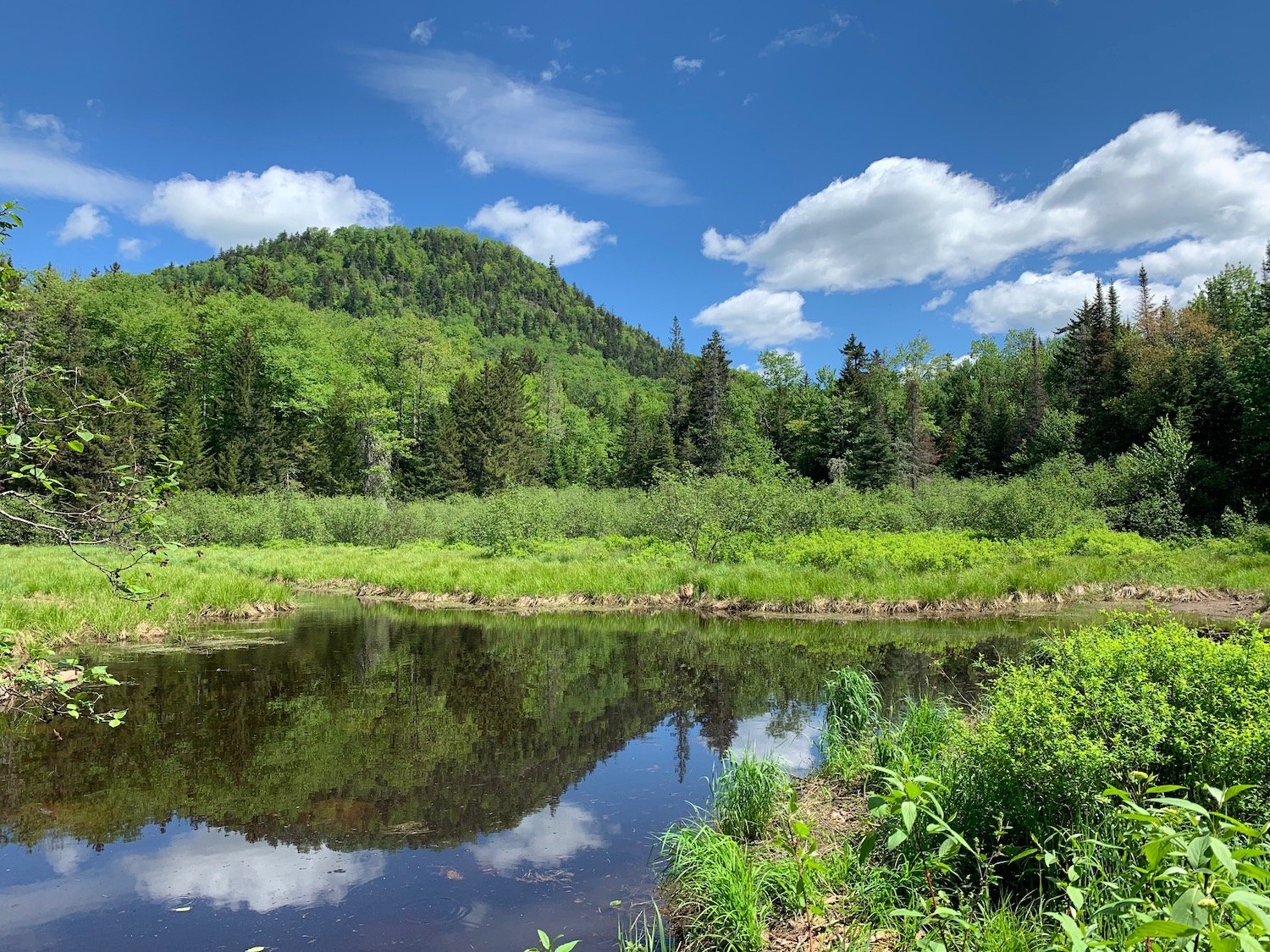
The East Branch Sacandaga River defines a substantial part of the eastern boundary of the Siamese Ponds Wilderness. If you do the 13-mile round trip hike from the Eleventh Mountain Trailhead on Route 8 to the Siamese Ponds, you’ll get a good look at it.